

Saturday, October 17, 2026
Cave Creek Thriller Trail Runs
On The Maricopa Trail
Now celebrating 17 years, the Cave Creek Thriller hosts four different distances and acts as the first race of the Fall Desert Runner Trail Series.
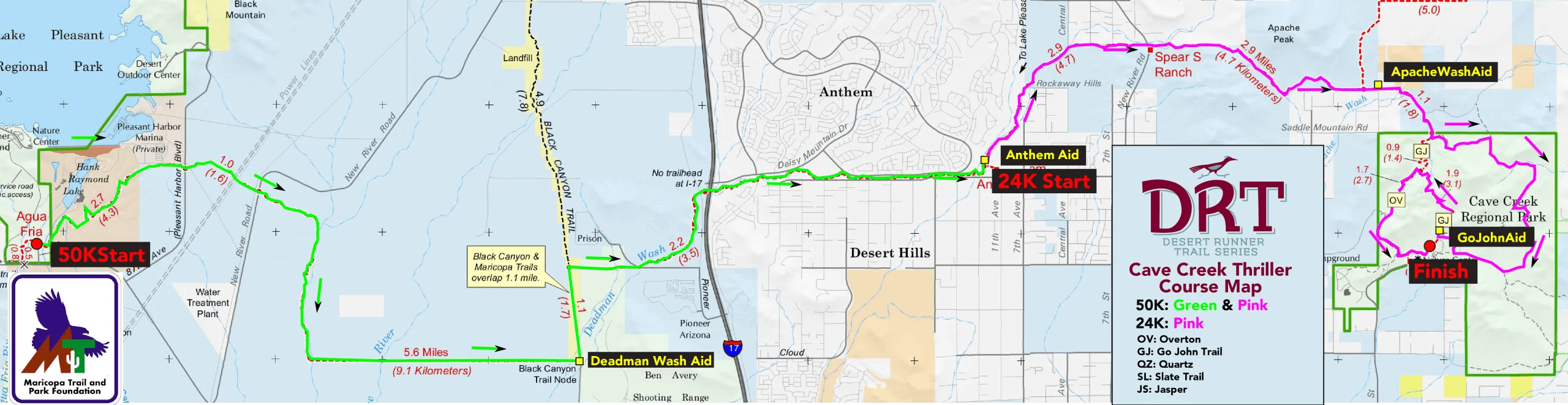
What began as a looped course within the Cave Creek Regional Park years ago, 50K runners will have the unique opportunity to connect two regional parks in one day on the Maricopa Trail!
*Distances may vary slightly each year due to permitting.
Start Times
6:30 AM – 50K Start at Agua Fria Trailhead (Maricopa Trail)
8:00 AM – 24K Start at Anthem Trailhead (Maricopa Trail)
8:00 AM – 5K Start at Cave Creek Regional Park
8:15 AM – 11K Start at Cave Creek Regional Park
Bib Pickup
Thursday, October 1512:00PM-5:00PM
Aravaipa Running Warehouse – Drive Thru
2401 S 24th St
Phoenix, AZ 85034
or
Saturday, October 17
Race Day Pickup
5:00-8:15AM
Cave Creek Regional Park
NOTE: We will have the bibs at the 24K & 50K starts if you are dropped off at either site.
Volunteer
We need help to make Cave Creek Thriller Trail Runs possible. Volunteer perks include Aravaipa race credits and race swag!Race Perks
Gender specific cut race shirtChip timed race results
Charity Beer Garden sponsored by Huss Brewing
Scenic and challenging Course
Well stocked aid station
Post race food & socializing
Finisher Award
Live Tracking
Follow the 2026 Cave Creek Thriller Trail Runs with live split points throughout the race.
Race Registration
| Until 4/30 | Until 8/14 | Until 10/12 | Race Week | |
| 5KM | $40 | $45 | $50 | $55 |
| 11KM | $55 | $65 | $75 | $85 |
| 24KM | $95 | $110 | $125 | $135 |
| 50KM | $135 | $150 | $165 | $175 |
*Pricing does not include taxes and Ultrasignup fees
Shirts are guaranteed if ordered by 9/12.
Entrant Limit
500 Runners
Entrant Lists
Course Information

Date | Saturday, October 17, 2026
Start Time | 6:30 am
Time Limit | 9.5 Hours (4:00 pm)
Distance | 31.2 Miles
Total Elevation Gain | 2,810 feet
Max Elevation | 2,518 feet
Women's Course Record | 4:20:22 - Megan Kupres (2021)
Men's Course Record | 3:38:51 - Eric LiPuma (2025)
50K runners will have the unique opportunity to connect two regional parks in one day! Starting at the Agua Fria Trailhead near Lake Pleasant, you’ll travel along the Maricopa Trail, a short section of the Black Canyon Trail, pass through the Anthem Trailhead along a desert corridor, climb past Spear S Ranch and finally enter Cave Creek Regional Park to finish along the Go John, Quartz & Overton Trails.
NOTE: Each year 50K runners go out too fast during the first miles (it is very runnable) and end up in trouble as they begin climbing at mile 18 and the temperature heats up (sometimes 90+ degrees). Please race smart to cross our finish line with an Ultra finish!


Aid stations every 3.0 to 9.25 miles including water, electrolyte drink, sweet snacks, salty snacks, and fruit. Please plan to run with at least one bottle of water.
50 KM: You will have a longer stretch without aid between the Start line and Deadman Aid. Terrain will be exposed, rocky, and steep. Come prepared with plenty of water to be successful in the later stages of the race!
This is a CUPLESS Race. Please come prepared with your own reusable cup or you will be able to purchase a cup on site.
| 50K | Course Distance (Miles) | Distance to Next (Miles) | Crew Access | Drop Bags |
| Start | 0 | 9.25 | Yes | |
| Deadman Aid | 9.25 | 6.75 | No | No |
| Anthem Aid | 16 | 6.3 | Yes | Yes |
| Apache Wash Aid | 22.3 | 5.8 | No | No |
| Go John Aid | 28.1 | 3.1 | No | No |
| Finish | 31.2 | Yes | Yes | |
Crews are welcome to support runners at the finish line at the Horse Staging Area as well as the Anthem Aid Station in the 50K race.
Pacers are not permitted for any race distance.
A drop bag will be allowed at the Anthem Aid station for 50K runners. Plan to bring your drop bag with you to the race start at the Agua Fria TH, whether on the shuttle or being dropped off by family/friend. We will move the drop bags from the 50K start immediately after the race begins. They will be transported to the finish line after the Anthem Aid Station closes down around 11:00 AM.
50K and 24K and 5K Runners: Parking is at Cave Creek Regional Park. There is NO PARKING at the Visitor Center or along the road inside the park! The park now charges $10 for a day pass and won’t be selling annual passes during your entry. Please bring exact change or your park pass for expediting everyone’s entry into the park.
50K and 24K – You can park near the finish line (inside regional park) and use our shuttle to your respective race start.
The 50K Shuttles depart at 5:30am. The 24K Shuttles depart at 7:15am. All of these buses will leave from INSIDE the parking lot at Race Headquarters.
You can also have your crew drop you off directly at the start and grab your bib race morning at your respective start line.
Race Day Schedule
Please arrive early to park, check in and warm up prior to your run. 50 Kilometer & 24 Kilometer runners will either need to find a ride to their starting line (which are not located at Cave Creek Regional Park-see above for more info) or take the race provided shuttle bus. See schedule below for what time to arrive for shuttle.
Restroom facilities are located at the start line at a permanent park facility as well as at the starting lines of both the 50K & 24K.
Timeline
5:00 AM – Packet pickup / race day registration begin
5:30 AM – 50K Shuttle Bus Pickup at Cave Creek Regional Park
6:06 AM – Begin Civil Twilight
6:30 AM – 50K Begins at Agua Fria TH on Maricopa Trail near Lake Pleasant Regional Park
6:31 AM – Sunrise
7:15 AM – 24K Shuttle Bus Pickup at Cave Creek Regional Park
7:15 AM – 11K Shuttle Pickup at Cave Creek Memorial Arena (outside of park)
8:00 AM – 24K Begins at Anthem TH on Maricopa Trail
8:10 AM – Partial Solar Eclipse Begins
8:00 AM – 5K Begins at Cave Creek Regional Park
8:15 AM – 11K Begins at Cave Creek Regional Park
4:00 PM – Overall cutoff / Race Ends
Anthem Aid Station: 11:00 AM (50K only)
9.5 hours for the 50K (4:00 PM).

Date | Saturday, October 17, 2026
Start Time | 8:00 am
Time Limit | 8+ Hours (4:00 pm Overall Cutoff)
Distance | 15.6 Miles
Total Elevation Gain | 1,960 feet
Max Elevation | 2,518 feet
Women's Course Record | 1:58:11 - Megan Kupres (2020)
Men's Course Record | 1:41:37 - Jordan Bramblett (2025)
24K Runners will start from the Anthem Trailhead, following the same route as the 50K runners along a desert corridor, climb past Spear S Ranch and finally enter Cave Creek Regional Park to finish along the Go John, Quartz & Overton Trails.

Aid stations every 3.0 to 8.6 miles including water, electrolyte drink, sweet snacks, salty snacks, and fruit. Please plan to run with at least one bottle of water.
25 KM: You will have a longer stretch without aid between Start and Apache Wash Aid. Terrain will be exposed, rocky, and steep. Come prepared with plenty of water to be successful in the later stages of the race!
This is a CUPLESS Race. Please come prepared with your own reusable cup or you will be able to purchase a cup on site.
| 25K | Course Distance (Miles) | Distance to Next (Miles) | Crew Access | Drop Bags |
| Start | 0 | 6.25 | Yes | |
| Apache Wash Aid | 6.25 | 5.75 | No | No |
| Go John Aid | 12 | 3.1 | No | No |
| Finish | 15.1 | Yes | Yes |
Crews are welcome to support runners at the finish line at the Horse Staging Area as well as the Anthem Aid Station in the 50K race.
Pacers are not permitted for any race distance.
We will have an area specified for your personal drop bag at the start/finish area that will allow for easy and quick access.
50K and 24K and 5K Runners: Parking is at Cave Creek Regional Park. There is NO PARKING at the Visitor Center or along the road inside the park! The park charges $7 for a day pass and won’t be selling annual passes during your entry. Please bring exact change or your park pass for expediting everyone’s entry into the park.
50K and 24K – You can park near the finish line (inside regional park) and use our shuttle to your respective race start.
The 50K Shuttles depart at 5:30am. The 24K Shuttles depart at 7:15am. All of these buses will leave from INSIDE the parking lot at Race Headquarters.
You can also have your crew drop you off directly at the start and grab your bib race morning at your respective start line.
Race Day Schedule
Please arrive early to park, check in and warm up prior to your run. 50 Kilometer & 24 Kilometer runners will either need to find a ride to their starting line (which are not located at Cave Creek Regional Park-see above for more info) or take the race provided shuttle bus. See schedule below for what time to arrive for shuttle.
Restroom facilities are located at the start line at a permanent park facility as well as at the starting lines of both the 50K & 24K.
Timeline
5:00 AM – Packet pickup / race day registration begin
5:30 AM – 50K Shuttle Bus Pickup at Cave Creek Regional Park
6:06 AM – Begin Civil Twilight
6:30 AM – 50K Begins at Agua Fria TH on Maricopa Trail near Lake Pleasant Regional Park
6:31 AM – Sunrise
7:15 AM – 24K Shuttle Bus Pickup at Cave Creek Regional Park
7:15 AM – 11K Shuttle Pickup at Cave Creek Memorial Arena (outside of park)
8:00 AM – 24K Begins at Anthem TH on Maricopa Trail
8:10 AM – Partial Solar Eclipse Begins
8:00 AM – 5K Begins at Cave Creek Regional Park
8:15 AM – 11K Begins at Cave Creek Regional Park
4:00 PM – Overall cutoff / Race Ends

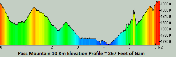
Date | Saturday, October 17, 2026
Start Time | 8:15 am
Time Limit | 7+ Hours (4:00 pm Overall Cutoff)
Distance | 7.3 Miles
Total Elevation Gain | 960 feet
Max Elevation | 2,481 feet
Women's Course Record | 56:53 - Andrea Felton (2014)
Men's Course Record | 45:26 - Marcos Gonzalez (2018)
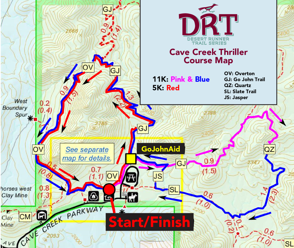

10KM and 5KM runners will have access to one on-course aid station, Go John Aid, which will be stocked water, electrolyte drink, sweet snacks, salty snacks, and fruit. Please plan to run with at least one bottle of water.
This is a CUPLESS Race. Please come prepared with your own reusable cup or you will be able to purchase a cup on site.
| 10K | Course Distance (Miles) | Distance to Next (Miles) | Crew Access | Drop Bags |
| Start | 0 | 4.03 | Yes | |
| Go John Aid | 4.03 | 3.31 | No | No |
| Finish | 7.34 | Yes | Yes |
Crews are welcome to support runners at the finish line at the Horse Staging Area as well as the Anthem Aid Station in the 50K race.
Pacers are not permitted for any race distance.
We will have an area specified for your personal drop bag at the start/finish area that will allow for easy and quick access.
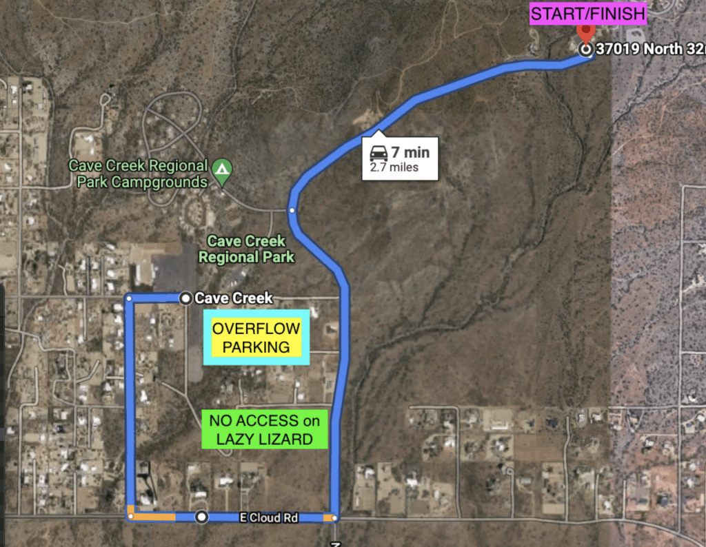
11K Runners you MUST PARK at the Cave Creek Memorial Arena and we will have SHUTTLE BUSES waiting for you. The address for the Arena is 37201 N 28th St, Cave Creek, AZ 85331. It is a short 7-10 minute ride from there. After the event we will have buses making continuous trips back until 11:30a. No 11K runners shall park inside Cave Creek Regional Park.
Shuttle Buses depart Cave Creek Memorial Arena Overflow lot at 7:15am.
We will have signs, flags and a staff member to assist you with parking. The bus will drop you off AND pick you up 1/4 mile walk from Race Headquarters.

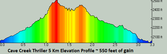
Date | Saturday, October 17, 2026
Start Time | 8:00 am
Time Limit | 8 Hours (4:00 pm Overall Cutoff)
Distance | 3.6 Miles
Total Elevation Gain | 542 feet
Max Elevation | 2,481 feet
Women's Course Record | 27:44 - Kristin Simonson (2015)
Men's Course Record | 21:00 - Dylan Arana (2014)
10KM and 5KM runners will have access to one on-course aid station, Go John Aid, which will be stocked water, electrolyte drink, sweet snacks, salty snacks, and fruit. Please plan to run with at least one bottle of water.
This is a CUPLESS Race. Please come prepared with your own reusable cup or you will be able to purchase a cup on site.
| 5K | Course Distance (Miles) | Distance to Next (Miles) | Crew Access | Drop Bags |
| Start | 0 | 0.3 | Yes | |
| Go John Aid | 0.3 | 3.3 | No | No |
| Finish | 3.6 | Yes | Yes |
Crews are welcome to support runners at the finish line at the Horse Staging Area as well as the Anthem Aid Station in the 50K race.
Pacers are not permitted for any race distance.
We will have an area specified for your personal drop bag at the start/finish area that will allow for easy and quick access.
Cave Creek Thriller (2022) Highlight Video
Additional Race Info
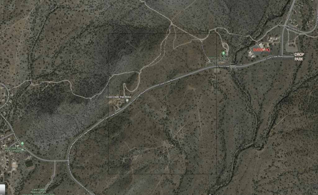
Parking / Start Area
The finish line is located at the Group Picnic Area within Cave Creek Regional Park. Overflow parking will be available in portions of the horse staging area parking lot or around the Tonalite Drive Loop approximately 1/4 mile from the start/finish area. We are not allowed to park at the Visitor Center.
Directions to Cave Creek Regional Park
From central Phoenix, take I-17 north to Carefree Hwy (SR 74). Exit Carefree Hwy. and travel east to 32nd St. (7 miles). Turn north on 32nd St. to the Cave Creek Regional Park entrance.
Address
37900 E Cave Creek Parkway
Cave Creek, AZ 85331
Park Entry Fee
Remember the park now charges a $10 park entry fee per vehicle (as of 1/1/26). Please arrive early and have correct change (cash) available on race morning for a smooth entry process. Carpool to save! If you are participating in the double (day & night runs) your pass is good all day.
11K Runners you MUST PARK at the Cave Creek Memorial Arena and we will have SHUTTLE BUSES waiting for you. The address for the Arena is 37201 N 28th St, Cave Creek, AZ 85331. It is a short 7-10 minute ride from there. After the event we will have buses making continuous trips back until 11:30a. No 11K runners shall park inside Cave Creek Regional Park.
Shuttle Buses depart Cave Creek Memorial Arena Overflow lot at 7:15am.
We will have signs, flags and a staff member to assist you with parking. The bus will drop you off AND pick you up 1/4 mile walk from Race Headquarters.
50K and 24K and 5K Runners: Parking is at Cave Creek Regional Park. There is NO PARKING at the Visitor Center or along the road inside the park! The park charges $7 for a day pass and won’t be selling annual passes during your entry. Please bring exact change or your park pass for expediting everyone’s entry into the park.
50K and 24K – You can park near the finish line (inside regional park) and use our shuttle to your respective race start. The 50K Shuttles depart at 5:30am. The 24K Shuttles depart at 7:15am. All of these buses will leave from INSIDE the parking lot at Race Headquarters.
You can also have your crew drop you off directly at the start and grab your bib race morning at your respective start line.
Race Day Schedule
Please arrive early to park, check in and warm up prior to your run. 50 Kilometer & 24 Kilometer runners will either need to find a ride to their starting line (which are not located at Cave Creek Regional Park-see above for more info) or take the race provided shuttle bus. See schedule below for what time to arrive for shuttle.
Restroom facilities are located at the start line at a permanent park facility as well as at the starting lines of both the 50K & 24K.
Timeline
5:00 AM – Packet pickup / race day registration begin
5:30 AM – 50K Shuttle Bus Pickup at Cave Creek Regional Park
6:06 AM – Begin Civil Twilight
6:30 AM – 50K Begins at Agua Fria TH on Maricopa Trail near Lake Pleasant Regional Park
6:31 AM – Sunrise
7:15 AM – 24K Shuttle Bus Pickup at Cave Creek Regional Park
7:15 AM – 11K Shuttle Pickup at Cave Creek Memorial Arena (outside of park)
8:00 AM – 24K Begins at Anthem TH on Maricopa Trail
8:00 AM – 5K Begins at Cave Creek Regional Park
8:15 AM – 11K Begins at Cave Creek Regional Park
4:00 PM – Overall cutoff / Race Ends
Landing back in October, temps can make for a HOT day in the desert! October average temperatures are highs in the 80s and lows in the 60s, but 90+ degree days are common. Forecast for Cave Creek, AZ
The race courses will be well marked with orange ribbons with black polka dots and reflective medallions. Trail junctions and turns will be marked with laminated signs. In addition, blue & white checkerboard plastic flagging will be hung to designate non-race or “WRONG WAY” trails. All runners are responsible for understanding the layout of the course. Please familiarize yourself with the course maps on our website prior to race day and/or print a map to bring along with you.
![]()
We will have our MedStar Solutions medical staff based at the start / finish headquarters to assist with first aid onsite. We reserve the right to pull you from the race if medical officials deem it necessary.
NOTE: Please do NOT call 911 in a medical emergency. Our medical team is highly trained and understands the terrain and driving access points. Please call the race day number and they will dispatch immediately.
Athletico Physical Therapy will be on-site offering post-race stretching services.
![]()
Athletico Physical Therapy is proud to be a Supporting Sponsor of the Desert Runner Trail Series. Athletico is a leading provider of orthopedic rehabilitation services to communities, employers, and athletes with more than 900 locations in 24 states and the District of Columbia, including several locations throughout the Greater Phoenix area. From training aches to post-race soreness, Athletico's here to keep you moving with purpose. Our endurance experts can address potential issues and provide personalized recovery plans.
Schedule your free assessment today.
Pets
For the safety of all runners, no pets are allowed on-course at the night runs. Any pets at the race must be on a leash at all times, respect park rules, and be supervised.
Camping
Cave Creek Regional Park offers a campground with 38 individual sites and a group camping area. Each site has a large parking area to accommodate up to a 45′ RV and is a “Developed Site,” with water and electrical hook-ups, dump station, a picnic table, a barbecue grill, and fire ring. Cave Creek Regional Park provides clean restrooms with flush toilets and hot water showers. All sites in the campground may be reserved online here: Camping reservations.
Awards
Awards to the top 3 male & female finishers at each distance.
All finishers will receive a finisher award.
Trail Running and Trash
Please respect the trails and the beauty of the desert by disposing of any trash at one of our aid stations.
Cupless Events
In an effort to continually lessen our race footprint, we are once again cupless for the Desert Runner Trail Series. We will have UltrAspire reusable cups available at registration and on race day or feel free to bring your own! To check them out or purchase one directly visit our website HERE.
Trail Etiquette
Remember to always remain on designed trails, no short cutting.
If you decide to use headphones, please be respectful of runners behind you attempting to pass. Also, remove ear buds as you approach aid stations or a road crossing.
Please do not listen to music with a speaker (yes, we know you listen to the best music).
This course includes some legit single track. If you are fast and attempting to pass, please alert the runner in front of you before flying past them. Likewise, if you hear a runner approaching you from behind, attempt to find a spot to allow the runner to pass.
As a general rule, when passing a runner, announce, “on your left.”
Uphill runners/hikers have the right of way to downhill runners. Remain in control as you descend and respect the other
Volunteer Helpers
If you would like to join our volunteer team, we are looking for help with event setup, aid station captains, aid station helpers, timing, photography, videography, social media, course sweep and event breakdown. Volunteer perks include a piece of Aravaipa merchandise or race goody and Aravaipa Race Credits. You can see our current opportunities and sign up here: Cave Creek Thriller Volunteer Form
We also hold the Thrasher Night Runs at this park the night before Thriller. Finish any distance at both races and receive a unique custom medal for completing our Double Down! Races for Thrasher begin at 6 p.m. and include a 5K, 11K, 22K, and 33K.
For the 2025-2026 Desert Runner Trail Series, Aravaipa Running will be working with the Wilderness Volunteers to assist in their mission of building and rehabilitating trails.
Proceeds from the beer garden will go directly to this Association. The Beer Garden is being sponsored by a local brewery: Huss Brewing.
Results & Photos
50K | Male – 3:38:51 – Eric LiPuma (’25) | Female – 4:20:22 – Megan Kupres (’21)
24K | Male – 1:41:37 – Jordan Bramblett (’25) | Female – 1:58:11 – Megan Kupres (’20)
11K | Male – 45:26 – Marco Gonzalez (’20) | Female – 56:03 – Andrea Felton (’14)
5K | Male – 21:00 – Dylan Arana (’14) | Female – 27:50 – Kristin Simonson (’15)
Past Distance Course Records:
31K | Male – 2:31:59 – Jules Miller (’13) | Female – 3:19:08 – Caris Markos (’13)
30K | Male – 2:21:50 – Jules Miller (’12) | Female – 3:03:41 – Michelle Lindsey (’12)
19K | Male – 1:44:31 – Alan Eder (’13) | Female – 2:00:08 – Elizabeth Rich (’13)
12K | Male – 56:57 – Josh Benson (’13) | Female – 1:03:51 – Lauren Besenfelder (’13)
10K | Male – 47:46 – Tim Merritt (’11) | Female – 56:12 – Lisa Raykowski (’11)
Results
2025 | Results
2024 | Results
2023 | Results
2022 | Results
2021 | Results
2020 | Results
2019 | Results
2018 | Results
2017 | 50K | 24K | 11K | 5K
2016 | 50K | 24K | 11K | 5K
2015 | 50K | 24K | 11K | 5K
2014 | 50K | 24K | 11K | 5K
2013 | 50K | 31K | 19K | 12K
2012 | 50K | 30K | 10K
2011 | 50K | 30K | 10K
2010 | 50K | 30K | 10K
2025 | Aravaipa Photo Gallery | Let’s Wander Photography
2024 | Aravaipa Photo Gallery | Let’s Wander Photography
2023 | Aravaipa Photo Gallery | On Course by Alec Torio | Let’s Wander Photography
2022 | Aravaipa Photo Gallery | Austin Corbett Photography
2021 | Aravaipa Photo Gallery | Let’s Wander Photography
2020 | Aravaipa Photo Gallery
2019 | Aravaipa Photo Gallery
2018 | Aravaipa Photo Gallery
2017 | Aravaipa Photo Gallery
2016 | Aravaipa Photo Gallery | SweetM Images
2015 | Aravaipa Photo Gallery
2014 | Aravaipa Photo Gallery
2013 | Aravaipa Photo Gallery
2012 | Aravaipa Photo Gallery | Joan Hellman
2011 | Aravaipa Photo Gallery | Manoj Nagalla | Bret Sarnquist
2010 | Aravaipa Photo Gallery

Thank you to our sponsors!

