McDowell Mountain Frenzy Trail Runs
Presented by:
Saturday, December 7, 2024
50M | 50K | 25K | 10M | 5M
McDowell Mountain Regional Park, Fountain Hills, AZ
7:00 AM – 50 Mile Start
7:30 AM – 50 Km Start
8:00 AM – 25 Km Start
8:15 AM – 10 Mile Start
8:30 AM – 5 Mile Start
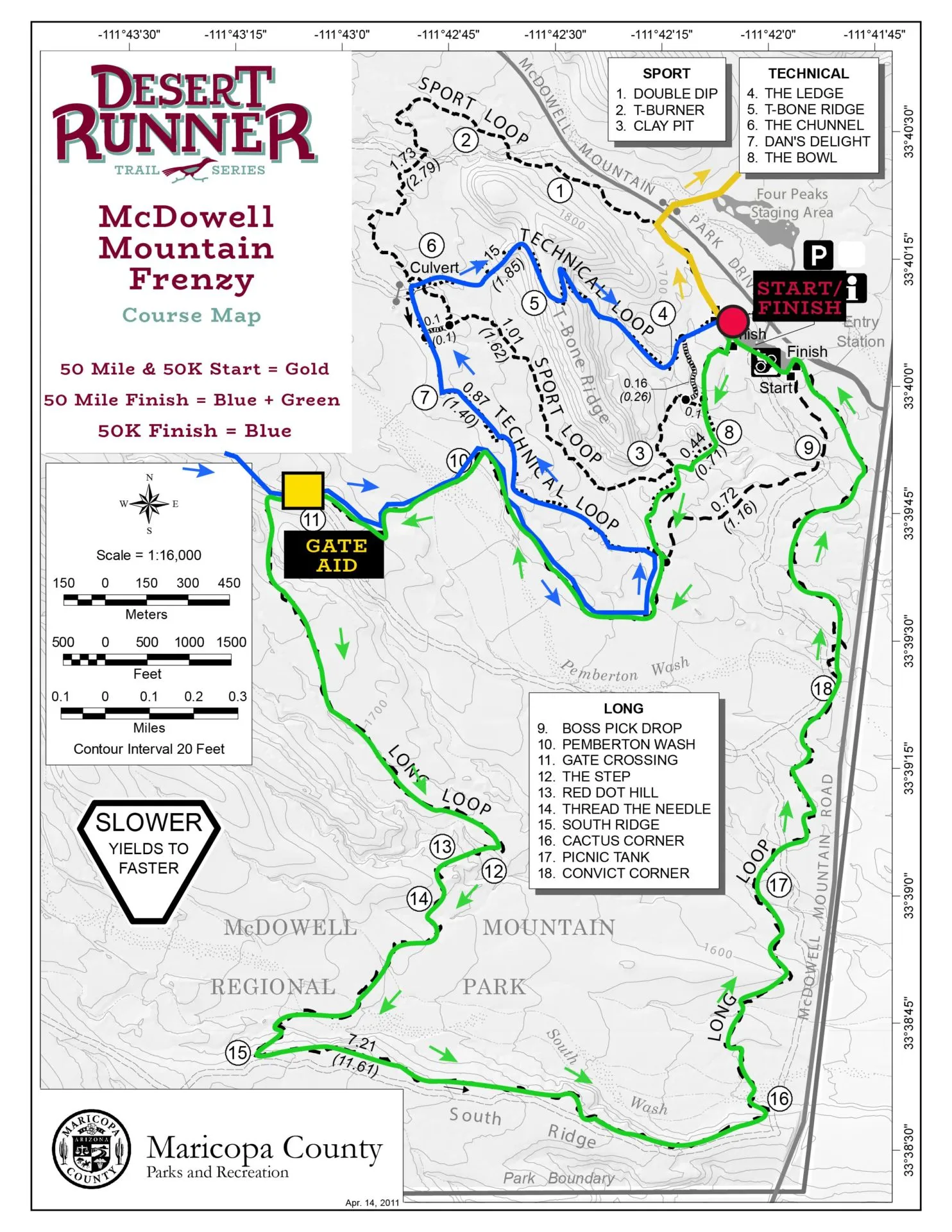
Explore the best of McDowell Mountain Regional Park with perfect winter weather in the Sonoran Desert. These trails runs are perfect for beginners and experienced runners alike that wind and weave their way through beautiful desert single track. The 50K is an ideal first ultra with a single loop course that briefly runs into Scottsdale’s McDowell Sonoran Preserve. Want the ultimate Frenzy experience? Take on the 50 miler that climbs high above Scottsdale to the revered Thompson Peak with 360 degree views of the Valley of the Sun.
The McDowell Mountain Frenzy is the third race in the Aravaipa Running – Fall Desert Runner Trail Series, Arizona’s premier trail & ultra run series.
RACE INFORMATION
Location
Competitive Track parking lot (first left after ranger booth)
McDowell Mountain Regional Park, Fountain Hills, AZ. Directions
Course Summary
This year’s 50 Mile & 50 Kilometer courses include rolling single track trails within McDowell Mountain Regional Park and a traverse of the McDowell Mountain Range within the City of Scottsdale’s McDowell Sonoran Preserve.
50 Mile runners: You will get a chance to run the Maricopa Trail via Gooseneck heading North towards Brown’s Ranch. This loop has you exit the regional park while running on the Gooseneck and Redbird trails within the Sonoran Preserve before returning to the Granite Tank aid station. You must hit this aid station twice before heading south on Gooseneck and Rocknob towards Dixie Mine aid station.
Additionally, you need to hit Dixie Mine aid station before climbing to the top of Thompson Peak, meaning you will also hit Dixie Mine aid twice. From the Dixie Mine aid station, you’ll continue making your way on the Dixie Mine trail with a nice little climb out of the aid station offering amazing views of the Four Peaks and Superstition Wilderness. After enjoying some great winding single track, you’ll connect back with the Pemberton Trail. You’ll then depart the Pemberton trail, heading towards the Competitive Track where you’ll actually come in to the finish line before heading back out on your final 8 mile loop.
The 25 Km, 10 Mile & 5 mile courses will all stay within the competitive track trails featuring winding single track trails and short but steep climbs and drops.
Weather
Forecast for Fountain Hills, AZ
Bib/Shirt Pickup
Friday, December 6
Packet Pickup 11a-6pm
Aravaipa Running Warehouse – Drive Thru
2401 S 24th St
Phoenix, AZ 85034
(602) 346-0554
————————————-
Saturday, December 7
Packet Pickup 6:15a-8:30 AM
McDowell Mountain Regional Park
————————————-
Aid Stations
Aid stations every 3-10.5 miles including water, ice, electrolyte drink (Gnarly Fuel 2O), sweet snacks, salty snacks, and fruit. We do not stock our aid stations with gels so please plan on bringing your own. Additionally, please plan to run with at least one bottle of water.
50 Mile and 50 Km runners: You have a stretch of 10.5 miles from Granite Tank aid to Dixie Mine aid that is exposed and challenging. We always see runners arrive at Dixie Mine without water and in rough shape. Utilize your drop bags and/or carry additional water during this stretch to make sure you keep your race moving!
Aid station distance chart:
50 Mile will have a drop bag at Granite Tank, Dixie Mine, and the start/finish
50K will have a drop bag at Dixie Mine
25K can have a drop at the finish line to access after the 10 Mile loop
Race Perks
Gender specific cut race shirt
Chip timed race results displayed at finish line
Scenic and challenging course on desert trails
Well stocked aid stations every 3-10.5 miles
Post race food (bagels, fresh fruit) & socializing
Charity Beer Garden
Finisher award
50 Mile finishers award
Awards
Awards to top 3 male & female finishers at each distance.
All finishers will receive a finisher award.
Points earned in the Desert Runner Trail Series.
Volunteer Helpers
If you would like to join our volunteer team, we are looking for help with event setup, aid station captains, aid station helpers, timing, photography, videography, social media and event breakdown. Volunteer perks include a piece of Aravaipa merchandise or race goody and Aravaipa Race Credits. You can see our current opportunities and sign up here: McDowell Mountain Frenzy Volunteer Form
REGISTRATION
Entry Fees*
Until 7/28 | Until 11/3 | Until 12/2 | Race Week | |
5 Mile | $45 | $50 | $55 | $60 |
10 Mile | $70 | $80 | $90 | $100 |
25 KM | $90 | $105 | $120 | $130 |
50 KM | $130 | $145 | $160 | $170 |
50 Mile | $170 | $185 | $200 | $210 |
*Pricing does not include tax.
Save $7.97 (including tax) with our no-shirt option! Shirts are only offered & guaranteed on race day if ordered by 11/11, otherwise shirts will be available if there are extras.
Entrant Limit
800 Runners
Registration Options
Online via Ultra Signup
Mail-In Entry Form
Online registration closes on Monday, 12/2, at 11:59PM. Registration will be available after online registration closes at all packet pickup locations and race day as long as we have not reached our capacity.
Double Down!
We also hold the Mayhem Night Runs at this park the same day as Frenzy. Finish any distance at both races and receive a unique custom medal for completing our Double Down! Races for Mayhem begin at 6 p.m. and include a 5 Mile, 10 Mile, and 25K.
Cut-Off
16 Hour Cut-off for the 50 Mile (11:00 PM).
15.5 Hour Cut-off for the 50 Kilometer (11:00 PM).
11 Hour Cut-off for 50 Mile (Mile 33.5) at Dixie Mine (6:00 PM). Runners need to be leaving Dixie Mine by 6:00 PM, not arriving.
13.5 Hour Cut-off for 50 Mile (Mile 42) at Start/Finish Thru Aid (8:30 PM) Runners need to be leaving Start/Finish Thru Aid by 8:30 PM, not arriving.
We will have our MedStar Solutions medical staff based at the start / finish headquarters. This team is here to help you with most basic and advanced first aid right on site. We reserve the right to pull you from the race if medical officials deem it necessary. Please understand that these decisions are made for your safety and do not argue. Continuing on in a state where you cannot safely navigate is a recipe for disaster and we are here to prevent that.
NOTE: If something happens to you or another runner, do NOT call 911 right away. Our medical team is highly trained in these scenarios, has been with us at this race the last three years and understands the terrain and driving access points. Please call their 24-hour number that will be answered by a real human being and they will dispatch accordingly.
MedStar Solutions Race Day Number: 480-269-4126
COURSE INFORMATION
Courses
The 5 mile, 10 mile and 25 Km runs take place on the rugged, rolling, and beautiful McDowell Competitive Track desert trails. The McDowell Competitive Track varies from 2 to 10 feet wide and is designed for challenging one’s skills.
The 50 Km features a single loop format including the fantastic single track of the Escondido Trail, parts of Pemberton loop and trails in the gorgeous McDowell Sonoran Preserve.
The 50 Mile course will run along the 50 km route but also includes a lollipop towards Saguaro Nest Trails and and also the infamous out and back to the top of Thompson Peak after completing 31 miles already (you’re welcome).
50 Miles
Elevation Gain 5,800 Feet | 1,770 Meters
50 Km
Elevation Gain 2,950 Feet | 900 Meters
25 Km
Elevation Gain 1,119 Feet | 341 Meters
10 Mile
Elevation Gain 763 Feet | 232 Meters
5 Mile
Elevation Gain 326 Feet | 99 Meters
Course Maps
Close up of 50 Mile Course ~ Miles 11.8-18.3
GPS Files
50M | Coros GPX | CalTopo Interactive Map
50K | Coros GPX | CalTopo Interactive Map
25K | Coros GPX | CalTopo Interactive Map
10M | Coros GPX | CalTopo Interactive Map
5M | Coros GPX | CalTopo Interactive Map
CalTopo Review
Desktop: Top of the screen will have an “Export” drop down menu. Select from GPX, KML, etc. in the top left. Click Export.
Phone: On left side of screen there will be 4 icons. Click the folder with pin drop, then Export. On the top will be a drop down menu title “Format.” Set it to the file type you want and then click Export. The export will load, and if you have a tracking app on your phone already (Gaia for example), it should ask to export directly to your app. Once the export is complete, you can use this during your race in airplane mode and always know where you are.
NOTE: It is important to make sure you set the file format appropriately or the file will not download as a GPX or KML.
RESULTS
Course Records
50 Mile | Male – 6:18:41 – Bryan Kerl (’22) | Female – 7:40:45 – Georgia Porter (’22)
50 Km | Male – 3:21:15 – Chris Myers (’22) | Female – 4:06:14 – Lauren Besenfelder Coury (’18)
25 Km | Male – 1:33:36 – Mike Popejoy (’15) | Female – 1:52:48- Ailsa Macdonald (’21)
10 Mile | Male – 1:00:41 – Forrest Boughner (’13) | Female – 1:15:55 – Katie Purpura (’14)
5 Mile | Male – 35:32 – Bill Dittman (’17) | Female – 38:34 – Brooke Andrus (’15)
Results
2023 | Results
2022 | Results
2021 | Results
2020 | Results
2019 | Results
2018 | Results
2017 | Results
2016 | 50M | 50Km | 25Km | 10M | 5M
2015 | 50M | 50Km | 25Km | 10M | 5M
2014 | 50M | 50Km | 25Km | 10M | 5M
2013 | 50M | 50Km | 25Km | 10M | 5M | Kids
2012 | 50M | 50Km | 25Km | 10M |
2011 | 50Km | 25Km | 10M | 5Km
2010 | 50Km | 25Km | 10M | 5Km
PHOTOS
2022 | Aravaipa Photo Gallery | Let’s Wander Photorgraphy
2022 | Aravaipa Photo Gallery
2021 | Aravaipa Photo Gallery | Let’s Wander Photorgraphy
2020 | Aravaipa Photo Gallery | Let’s Wander Photography
2019 | Aravaipa Photo Gallery
2018 | Aravaipa Photo Gallery
2017 | Aravaipa Photo Gallery | SweetM Images
2016 | Aravaipa Photo Gallery
2015 | Aravaipa Photo Gallery
2014 | Aravaipa Photo Gallery
2013 | Aravaipa Photo Gallery
2012 | Aravaipa Photo Gallery | Justin Lutick
2011 | Aravaipa Photo Gallery
12/2010 | Aravaipa Photo Gallery
1/2010 | Aravaipa Photo Gallery
RACE DAY INFORMATION
Race Day Schedule
Please arrive early to park, check in and warm up prior to your run. Restroom facilities are located at the start line at a permanent park facility.
Timeline
6:15 AM – Packet pickup / race day registration begin
6:48 AM – Begin civil twilight
7:00 AM – 50 Mile Starts
7:14 AM – Sunrise
7:30 AM – 50 Kilometer Starts
8:00 AM – 25 Kilometer Starts
8:15 AM – 10 Mile Starts
8:30 AM – 5 Mile Starts
5:21 PM – Sunset
5:47 PM – End civil twilight
6:00 PM – Dixie Mine Aid Station Cutoff
6:00 PM – Mayhem Night Runs Begins
8:30 PM – 50 Mile Start/Finish Aid (Mile 42) Cutoff
11:00 PM – 50 Mile & 50 Km Final Cutoff / All Races End
Park Entry Fee
Remember the park now charges a $7 park entry fee per vehicle. Please arrive early and have correct change (cash) available on race morning for a smooth entry process. Carpool to save!
Trail Running & Trash
Please respect the trails and the beauty of the desert by disposing of any trash at one of our aid stations.
Cupless Events: In an effort to continually lessen our race footprint, we are expanding our cupless events to the Desert Runner Trail Series. We will have UltrAspire reusable cups available at registration and on race day or feel free to bring your own!
Trail Etiquette
Jerk Rule #1: Under no circumstances is it OK to yell at or be rude to a volunteer or staff member. Do not rely on volunteers, photographer’s or other staff persons to direct you on your course. It is YOUR responsibility to know your course and follow the course signs. If we get word of this occurring, we reserve the right to DQ you from the race. These people are volunteering their free time to assist you in reaching the finish line and are doing everything they can to get you there. Thank them and keep moving.
Music: If you decide to use headphones, please be respectful of runners behind you attempting to pass. Also, remove ear buds as you approach aid stations, volunteers, or a road crossing.
Please do not listen to music with a speaker (yes, we know you listen to the best music).
Trail Usage: Remember to always remain on designed trails, no short cutting. Our courses are marked in a manner that allows you to run your advertised distance in the order we have it designed. If you get off course it is your responsibility to return to the point where you got off and continue from there. Any bonus miles you accrue during this time are just that, bonus. Chin up and continue your forward progress.
This course includes some legit single track. If you are fast and attempting to pass, please alert the runner in front of you before flying past them. Likewise, if you hear a runner approaching you from behind, attempt to find a spot to allow the runner to pass. As a general rule, when passing a runner, announce, “on your left.”
Uphill runners/hikers have the right of way to downhill runners. Remain in control as you descend and respect the other runners.
Everyone is after the same goal here so let’s be respectful of each other’s races and have fun. Please.
Race Timing
We will be utilizing a chip timing system at this event to record your time at the finish. You will be provided with a timing chip attached to the back side of your race bib. It is important to pin this bib on the FRONT of your body, not crease, or fold the the timing chip to ensure your finish time is read. There will also be two remote timing points on course. Friends and family can follow along on live.aravaiparunning.com
Drop Bags
50 MILERS: Similarly, please plan on arriving to Granite Tank I (mile 11.6) without your drop bags. Once you return from your Gooseneck Loop to Granite Tank Aid (mile 18), they will be there. It is possible they will be there for the first time arriving but we aren’t able to guarantee that.
A drop bag will be allowed at Dixie Mine Aid Station (mile 22) for 50 Km runners.
Drop bags for 50 Mile runners will be allowed at Granite Tank, Dixie Mine, and Start/Finish Aid Stations. Please have your drop bags labeled with your name, bib number and aid station location and place in the appropriate signed location by 7:00 AM (50 mile) and 7:30 AM (50K) on race morning. The truck will leave almost immediately after the 50K start for Dixie Mine Aid station and there will not be a second trip! Bags will be returned to the finish line as aid stations break down. Please keep in mind Dixie Mine will be one of the last to break down, so your drop bag may not be back from that aid station until close to 8:00 PM. We will do our best to bring used drop bags back to the finish throughout the day as well.
NOTE: Once you have finished with your drop bag, please ask the volunteers to keep it in a “used drop bag” area in case we are able to bring them back before the station closes.
Crews and Pacers
Crews are welcome to hang out at our start/finish headquarters where the 50 milers will come through around mile 42. There are no other crew access locations due to permit restrictions and road access.
Pacers are allowed for 50 milers on their final loop within the Competitive Track, beginning around mile 42. Pacers are not allowed for any other distances. No pacer bib is required but please inform our timing tent that you will be heading out with a pacer for your final section.
Aid Station Helpers
We cannot produce these trail runs without the help of our amazing volunteer team. You can even help and run on race day. If you would like to join our volunteer team, we are looking for help with event setup, aid station captains, aid station helpers, timing, photography, videography, social media, course sweep and event breakdown. Volunteer perks include a piece of Aravaipa merchandise or race goody and Aravaipa Race Credits. You can see our current opportunities and sign up here: McDowell Mountain Frenzy Volunteer Form
Course Marking
The race courses will be well marked with orange plastic ribbons with black polka dots. Trail junctions and turns will be well marked with colored laminated signs that correspond with your race’s color (5M = Blue, 10M = Green, 25K = Yellow, 50K = Red, 50M = White). Please pay attention to these signs at each junction as there are multiple race distances and race courses! In order to be given an official finish, you are expected to complete your course in the order it was designed.
In addition, blue & white checkerboard plastic flagging will be hung to designate non-race or “WRONG WAY” trails. All runners are responsible for understanding the layout of the courses. Please familiarize yourself with the course maps on our website prior to race day and/or print a map to bring along with you.
And as always, don’t just follow runners through an intersection- check your signs and proceed.
Parking / Start Area
The start/finish line is located at the competitive track parking area. Overflow parking will be across the street in the Four Peaks Staging Area.
Charity Beer Garden
For the 2024-2025 Desert Runner Trail Series, Aravaipa Running will be working with the Southwest Wildlife Conservation to assist in their mission rescues and rehabilitates wildlife that has been injured, displaced, and orphaned. Once rehabilitated, they are returned to the wild. Sanctuary is provided to animals that cannot be released back to the wild.
Proceeds from the beer garden will go directly to this Association. The Beer Garden is being sponsored by a local brewery: Huss Brewing.
Hotels
We are working on securing a new hotel partner for the 2023 race. Check back for details.
Camping
McDowell Mountain Regional Park offers 96 individual sites for tent or RV camping. Sites in the campground may be reserved online at Maricopa County Parks. Participants can also camp in the group campground for $22/night. Payment is taken at the park entrance. The group campground is 2.5 miles away from the event.
NOTE: The park now has automatic gates that close at 8pm, restricting access into the park “after hours.”
Directions
From central Phoenix, take Loop 202 east to Beeline Highway (SR 87). Continue northeast on SR 87 to Shea Blvd. Travel west on Shea Blvd. to Saguaro Blvd.; turn north. Continue through Town of Fountain Hills to Fountain Hills Blvd; turn right and travel four miles to the McDowell Mountain Regional Park entrance.
Address
16300 McDowell Mountain Park Dr.
MMRP Arizona 85255